I’m off again! This time I’m on my way to the south west of England to attempt the difficult South West Coast Path. I'm off on Wednesday 11th May, almost exactly a year after my Coast-to-coast walk.
In case you followed this blog and would like to follow me on the South West Coast Path, I thought I would let you know by posting here.
The link below will take you to the new blog, though there won't be a post until Wednesday evening! If you would like to receive daily email notifications of the latest posts, please enter your email address at the top right, and follow the instructions. Please be sure to click on the link you receive in an email from Feedburner/Google. It is perfectly safe!
It will be great to have you along….
South West Coast Path
Monday 9 May 2016
Wednesday 29 April 2015
Time to Walk: Coast-to-coast
I’m off again! This time I’m attempting the Coast-to coast walk popularised by Alfred Wainwright, the great fell walker of the 1970s. I set off on May 6th 2015, from St Bees on the coast of Cumbria, heading for Robin Hood’s Bay on the North Sea Coast.
In case anyone who followed this blog would like to follow me on the Coast-to-coast, I thought I would let you know by posting here.
The link below will take you to the new blog, where you will find the “Day 0” post. If you would like to receive daily email notifications of the latest posts, please add your email address at the top of the sidebar on the right of the “Day 0” post, click on the link, and follow the instructions.
It will be great to have you along….
http://corrigendus4.blogspot.co.uk/
Sunday 30 March 2014
Time to walk: Peddars Way and Norfolk Coast Path
It’s spring again and, predictably, I’m about to set
out on another national trail. This year,
it’s really two walks combined into one National trail. Just in case anyone who
followed my previous blogs would like to do so again, I thought I would let you
know by posting on my original LEJOG blog.
This link will take you to the new blog, where you’ll find the “Day 0” post.
http://corrigendus3.blogspot.co.uk
The walk actually starts on Thursday 3rd April, and the Day1 post will appear that evening.
This link will take you to the new blog, where you’ll find the “Day 0” post.
http://corrigendus3.blogspot.co.uk
The walk actually starts on Thursday 3rd April, and the Day1 post will appear that evening.
Wednesday 24 April 2013
Time to walk the Coast of Pembrokeshire
It’s that time of the year again! I’m about to set out on another national trail. This time it’s the hugely alluring southern coast of Wales. Just in case any of those kind people who followed my previous blogs would like to do so again, I thought it would be a good idea to post on my original LEJOG blog.
This link will take you to the new blog, where, all being well, you’ll find the “Day 0” post from Amroth.
http://corrigendus2.blogspot.co.uk
Now, off I go! All I have to worry about is the weather…..
This link will take you to the new blog, where, all being well, you’ll find the “Day 0” post from Amroth.
http://corrigendus2.blogspot.co.uk
Now, off I go! All I have to worry about is the weather…..
Friday 4 May 2012
Time to Walk the Cotswold Way!
A year ago today, I was approaching Bristol after walking through the South West of England from Land’s End. Next Wednesday, I will set out on the Cotswold Way. It seems I’m not going to be able to get the walking bug out of my system that easily!
After due consideration and on the advice of one or two friends, I have decided to continue the blog. However, given that so many readers had trouble with it, especially in making comments on the website, I have decided to migrate the future blog to WordPress. This will have the benefit that if you are reading this post in an email sent automatically from the site, you will no longer be troubled!
Unless of course, masochistically you do wish to be further disturbed on a daily basis! In this unlikely event, you have work to do!
This link (http://corrigendus2.wordpress.com/) will take you through to the new WordPress blog. When you get there, click on the “Follow” button on the right-hand side, under the option “FOLLOW BLOG BY EMAIL”, and do as WordPress instructs, and if all goes according to plan, you will be signed up to receive the daily email. If you prefer to read the post on the web, just click on the title of the post in the email and it will take you right through to the post in your preferred browser, where you will also be able to make comments as you see fit.
The good news is that the Cotswold Way will only take about a week, so your email will not be too overloaded!
I look forward to seeing you on the other side!
Friday 5 August 2011
LEJOG Postscript
It's hard to believe, but it is just over a week since I arrived home! My journey is gradually beginning to fade, but there are all sorts of little reminders; for instance the last blister plaster came off this morning! It has been very special indeed to be reunited with Veronica. Both daughters have been around to visit and it has been delightful to see them. Still, I wake up in the middle of the night, wondering where the loo is in this B&B and suddenly realise that it is in a very familiar place, and that person next to me is very familiar as well! I lost a stone (6.4kg, 14lbs) on my journey but the test will be to see whether I can keep the weight off!
For some reason, the last blog post of my journey did not get distributed to those people who had subscribed by email. I received a number of emails asking whether Veronica ran me over on the last leg!! I'm pleased to report that the oversight was nothing more than another glitch at Google and it gave me an excuse to write this very final post, just to round the whole thing off.
In my very nerdy way, I have spent a couple of days analysing the statistics of the journey and I thought I might share these with you for better or for worse. I decided that it might be of interest to split the journey by the type of walk rather than just the region, so differentiating between the National Trails and the Roadwork, as well as some regional information. You will need to click on each graph to see the detail, if you are at all interested!
But first, in case you didn't see that final post on the internet, here is the proof that I made it!

And here is a visual summary of the whole journey. If you look at the picture above you will see that the shortest route from LE to JOG is 874miles. My journey was 1202 miles and in the map below you can see quite clearly that the deviations to do the National Trails added more than 300miles to the journey.


 From the beginning I thought that I would average about 16km (10mi) per day, hoping that as I got fitter and stronger, the distances would increase. In my training exercises, I remember feeling tired after as little as 10km (6mi), and wondering how I would cope with much longer distances with a full pack. As it turned out, I did manage the expected distances and over time, they did increase. The trend line in the graph above shows this quite clearly. Though to be honest, the graph also shows that when the distances were pre-ordained such as on the national trails, I did do longer distances, but when the choice was my own, I backed off! Pah!!

 This graph is a little more interesting! First, it shows that the National Trails were in general more demanding, which isn't surprising, though what did surprise me is that the roadwork wasn't that far behind. I was staggered by the statistics for the Pennine Way. In my recollection, there were lots of ups and downs all through the Pennine Way, whereas one would have thought that the walk along the coast of North East Scotland would have been as flat as a pancake! Not so! They turned out to be much the same. What was also very surprising was that the walk along the Great Glen Way, which one would have expected to be all very flat given that it was supposed to be along canals and lochs, turned out to be really quite hilly! I was also surprised that Offa's Dyke and the West Highland Way were much the same! You would have thought that having done the walk myself, I wouldn't have been all that surprised by these statistics, but it just goes to show!!


For some reason, the last blog post of my journey did not get distributed to those people who had subscribed by email. I received a number of emails asking whether Veronica ran me over on the last leg!! I'm pleased to report that the oversight was nothing more than another glitch at Google and it gave me an excuse to write this very final post, just to round the whole thing off.
In my very nerdy way, I have spent a couple of days analysing the statistics of the journey and I thought I might share these with you for better or for worse. I decided that it might be of interest to split the journey by the type of walk rather than just the region, so differentiating between the National Trails and the Roadwork, as well as some regional information. You will need to click on each graph to see the detail, if you are at all interested!
But first, in case you didn't see that final post on the internet, here is the proof that I made it!


The individual flags on the map each represent daily waypoints, actually the location of the B&B for each night.
(The data in the graphs immediately below are all metric. If you are more of an Imperial persuasion, please move down the post to the end of the metric commentary, whereafter I have duplicated all the information in Imperial Units)

Unsurprisingly, the total distance walked correlates closely with the number of days on each phase of the journey. South West England and the Pennine way together made up almost 50% of the total distance and Scotland around a third.
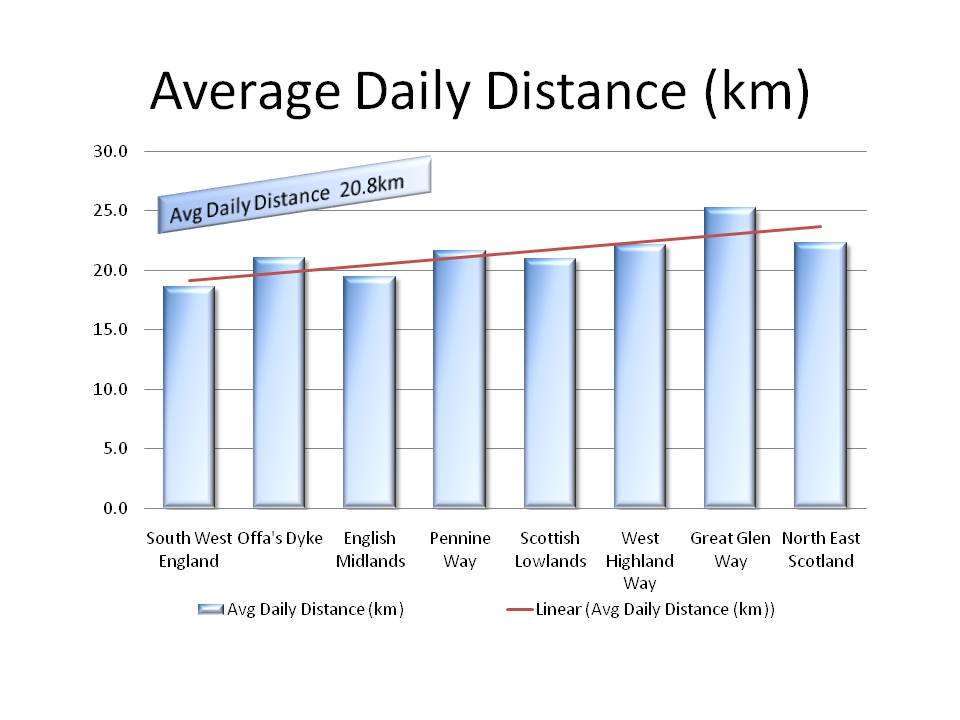
From the beginning I thought that I would average about 16km (10mi) per day, hoping that as I got fitter and stronger, the distances would increase. In my training exercises, I remember feeling tired after as little as 10km (6mi), and wondering how I would cope with much longer distances with a full pack. As it turned out, I did manage the expected distances and over time, they did increase. The trend line in the graph above shows this quite clearly. Though to be honest, the graph also shows that when the distances were pre-ordained such as on the national trails, I did do longer distances, but when the choice was my own, I backed off! Pah!!

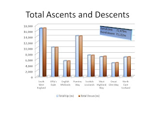
This graph doesn't show very much! In fact all it shows is how much I climbed and descended which turned out unsurprisingly to be closely correlated with the distances I walked (see above!)! I included it only because, as I said in the previous post, it does show a lot of climbing and descending!
This graph is a little more interesting! First, it shows that the National Trails were in general more demanding, which isn't surprising, though what did surprise me is that the roadwork wasn't that far behind. I was staggered by the statistics for the Pennine Way. In my recollection, there were lots of ups and downs all through the Pennine Way, whereas one would have thought that the walk along the coast of North East Scotland would have been as flat as a pancake! Not so! They turned out to be much the same. What was also very surprising was that the walk along the Great Glen Way, which one would have expected to be all very flat given that it was supposed to be along canals and lochs, turned out to be really quite hilly! I was also surprised that Offa's Dyke and the West Highland Way were much the same! You would have thought that having done the walk myself, I wouldn't have been all that surprised by these statistics, but it just goes to show!!

The trend lines in this graph show that I walked faster as I got fitter, and more interestingly, that I took fewer rest periods along the way as time progressed. My gadget was unforgiving in that it regarded every stop along the way, to take a photo or a pee, to look at my map or the view, as a definite stop. Of course it also had a negative view about lunch stops or tea breaks. The stats show that as time progressed, I became fixated on just keeping walking (the difference between the total time and the walking time reduced). This was partly due to increased fitness and partly due to Scottish midges, though they were far less of a problem than I had anticipated. The major reason was that I grew comfortable with the walk and just liked to keep plodding on. Strange really!

This graph slices and dices the information in a different way. Here I have taken the same information but looked at it on the basis of National Trails vs. Roadwork. I have to assume no-one reading this blog will be silly enough to do the the whole of LEJOG, but they might be interested in the comparison. It shows that the total amount of roadwork was not significantly greater than the total time on the Trails, either in terms of distance or days, though because I was lazier on the roads, they did take proportionately more time.
It also shows that I did walk larger distances on the Trails and I did climb higher on the Trails, none of which is surprising!

Finally, for those who didn't see the last post, here is the weather postcast! Again, it doesn't show very much, other than how lucky I was to choose the driest April in recorded history to start my walk and that this luck persisted into Scotland, when the really wet weather went south. It also shows Wales and Northern England were wetter! I actually got drenched to the skin on only about six days, which unsurprisingly correlates very closely to the number of days that I spent walking with Englishmen (or women!). Quod erat demonstrandum! (OK, I do admit that they weren't always with me on the the really wet days, but they are devious enough to confuse the weather a little!!)

And now, having presumed to take up so much of your time over so lengthy a period, it is time to close this Blog. I can only reiterate that this entire journey would have been so much lonelier without your participation, both in the comments and in the private emails. You will understand that seeing Veronica at Journey's End was just wonderful, but somehow I feel that the whole thing would have been empty without your participation. Thank you!!
(As I promised, the Imperial data follows!)

Unsurprisingly, the total distance walked correlates closely with the number of days on each phase of the journey. South West England and the Penine way together made up almost 50% of the total distance and Scotland around a third.

This graph doesn't show very much! In fact all it shows is how much I climbed and descended which turned out unsurprisingly to be closely correlated with the distances I walked (see above!)! I included it only because, as I said in the previous post, it does show a lot of climbing and descending!


The trend lines in this graph show that I walked faster as I got fitter, and more interestingly, that I took fewer rest periods along the way as time progressed. My gadget was unforgiving in that it regarded every stop along the way, to take a photo or a pee, to look at my map or the view, as a definite stop. Of course it also had a negative view about lunch stops or tea breaks. The stats show that as time progressed, I became fixated on just keeping walking (the difference between the total time and the walking time reduced). This was partly due to increased fitness and partly due to Scottish midges, though they were far less of a problem than I had anticipated. The major reason was that I grew comfortable with the walk and just liked to keep plodding on. Strange really!
The other interesting observation is that I clearly walked more slowly on the National Trails than on the roads. This is not surprising. Often on the National Trails, I was walking with other people, and their pace governed mine, but also, the National Trails involved many more ups and downs and as Mr Naismith decreed many posts ago, this will always slow you up. What interests me is that by the time I got to the Great Glen Way, I was just going for it! I tried to persuade myself that I should stay in the moment and appreciate everything along the way from start to finish, but maybe I turned out to be human after all! The end was nigh, I was fitter and I was going for it! By the time I got to North East Scotland, I was flying, despite the ups and downs. Clearly, I wanted to be reunited with Veronica!

This graph slices and dices the information in a different way. Here I have taken the same information but looked at it on the basis of National Trails vs. Roadwork. I have to assume no-one reading this blog will be silly enough to do the the whole of LEJOG, but they might be interested in the comparison. It shows that the total amount of roadwork was not significantly greater than the total time on the Trails, either in terms of distance or days, though because I was lazier on the roads, they did take proportionately more time.
It also shows that I did walk larger distances on the Trails and I did climb higher on the Trails, none of which is surprising!
Finally, for those who didn't see the last post, here is the weather postcast! Again, it doesn't show very much, other than how lucky I was to choose the driest April in recorded history to start my walk and that this luck persisted into Scotland, when the really wet weather went south. It also shows Wales and Northern England were wetter! I actually got drenched to the skin on only about six days, which unsurprisingly correlates very closely to the number of days that I spent walking with Englishmen (or women!). Quod erat demonstrandum! (OK, I do admit that they weren't always with me on the the really wet days, but they are devious enough to confuse the weather a little!!)
And now, having presumed to take up so much of your time over so lengthy a period, it is time to close this Blog. I can only reiterate that this entire journey would have been so much lonelier without your participation, both in the comments and in the private emails. You will understand that seeing Veronica at Journey's End was just wonderful, but somehow I feel that the whole thing would have been empty without your participation. Thank you!!
Tuesday 26 July 2011
LEJOG Day 93: Keiss to John o'Groats; Statistics
| Weather: Cloudy with gentle northerly |
| Distance covered today: 14.6km (9.1mi) |
| Last night's B&B: Sinclair Bay Hotel (£45) |
| Cumulative distance: 1934.0km (1201.7mi)/ % Complete: 100.0% |
| GPS satellite track of today's route: Day 93 (click!) |

Journey's End
In the tables which follow, the headings refer to the following geographic areas:
SW England: Land’s End to the Bristol Channel, including Cornwall, Devon and Somerset
Wales: This refers essentially to Offa’s Dyke, some of which is in England, but for simplicity’s sake, I have grouped the whole of this part of the trail as “Wales”. It includes the tongue of land that is Wales sticking into England in the north.
N England: This includes the cross-country bit that took me to the start of the second leg of the Pennine Way and then all the way up the Pennine Way until I left England after Byrness to follow the Roman Road of Dere Street into Scotland
Scotland: Obviously this refers to the rest of the journey, including the route across Scotland from Jedburgh to Milngavie, up the West Highland Way, across the Great Glen and then up the A9 (and A99) from Inverness to John o’Groats
Metric | SW England | Wales | N England | Scotland | Overall |
Total Distance (km) | 466 | 257 | 487 | 724 | 1934 |
Avg daily dist (km) | 18.6 | 21.4 | 20.3 | 22.6 | 20.8 |
Walking Days | 25 | 12 | 24 | 32 | 93 |
Total Up (m) | 16918 | 11044 | 17915 | 27103 | 72979 |
Total Down (m) | 16995 | 11091 | 17625 | 27411 | 73122 |
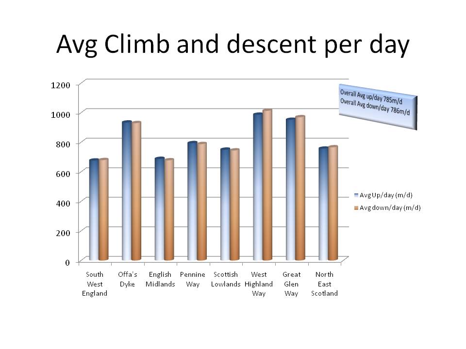
Avg Up (m/per day) | 677 | 920 | 746 | 847 | 785 |
Avg Down (m/per day) | 680 | 924 | 734 | 857 | 786 |
Avg speed walking (km/h) | 4.6 | 4.2 | 4.5 | 4.9 | 4.6 |
Avg speed overall (km/h) | 3.5 | 3.2 | 3.6 | 4.3 | 3.8 |
For those of an Imperial persuasion:
UK (Imperial) | SW England | Wales | N England | Scotland | Overall |
Total Distance (mi) | 289.5 | 159.8 | 302.6 | 449.8 | 1201.7 |
Avg daily dist (mi) | 11.6 | 13.3 | 12.6 | 14.1 | 12.9 |
Walking Days | 25 | 12 | 24 | 32 | 93 |
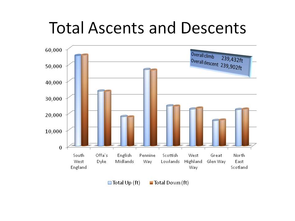
Total Up (ft) | 55505 | 36232 | 58775 | 88920 | 239432 |
Total Down (ft) | 55757 | 36388 | 57826 | 89931 | 239902 |
Avg Up (ft/per day) | 2220 | 3019 | 2449 | 2779 | 2575 |
Avg Down (ft/per day) | 2230 | 3032 | 2409 | 2810 | 2580 |
Avg speed walking (mph) | 2.8 | 2.6 | 2.8 | 3.0 | 2.9 |
Avg speed overall (mph) | 2.2 | 2.0 | 2.3 | 2.7 | 2.3 |
The numbers show the relative difficulty of Offa’s Dyke, which is a much underestimated national trail. Although there are no great peaks, the grain of the land means that there are many ups and downs and the daily distances are extensive. In my case, I had my most severe physical problems on this stretch, but the advantage was that it toughened me up for the challenges in the Pennines and Scotland. I find it fascinating that I did more climbs and descents in Wales than in any other leg of the journey.
The numbers also show the vast area that is Scotland. For those Southerners who rarely get north of Watford, it is always interesting to learn just how large a proportion of Britain Scotland occupies. It seems unfair that the Scots have both the most beautiful scenery and the most land. A pity about the weather, though I was dead lucky! See below!!
In terms of height, which for me was initially the most demanding, the figures show that my journey included the equivalent of climbing and descending Mount Everest 8 times, or Table Mountain in Cape Town 80 times, or almost once a day!
The figures show a gradual increase in fitness. After the early, easy times in the South West, there is the shock of Offa’s Dyke, but after that the daily distances and the speed of walking gradually increase. The figures also show that walking on roads is easier and faster than on the National Trails, though it may be less enjoyable!
It is also apparent that in Scotland, I needed far lest rest during my walking day, and although the midges turned out to be no problem at all despite my initial concerns, I became quite used to walking the whole daily distance without stopping. I found that stopping half-way merely increased my aches and pains, so the right answer was to press on and relax at my destination. (The recorded stopping times are slightly misleading: they include stopping for checking a map, reading a notice, changing my rain gear, having a pee, and all other temporary interruptions. The machine was unrelenting!)
For me, the other lesson from the statistics, coupled with my own experience, is that I didn’t actually get that much fitter along the way. I had expected that by the end, I would be finding it very much easier to cover the daily distances than at the beginning. The statistics do show an improvement, but less than I would have expected. And certainly, there was no decrease in the amount of effort required. Probably a sign of age!
The Weather
Probably the single most significant indicator of enjoyment on a long-distance walk is the weather. I tried to convince myself that bad weather didn’t make a difference provided I was dry and warm, but sometimes I was drenched to the skin and it did make a difference! As it turned out, I couldn’t have been luckier! I chose the perfect year for my walk and the perfect timing within that year! April was the driest month on record and although the whole country went through a wet patch in May and June, by July Scotland was dry and all the rain was in the south!
The statistics don’t indicate much about regional weather patterns; they just show how lucky I was!
SW England | Wales | N England | Scotland | Overall | |
Sunny days | 18 | 4 | 9 | 12 | 43 |
Cloudy days | 7 | 3 | 6 | 14 | 30 |
Rainy days | 0 | 5 | 9 | 6 | 20 |
% sunny | 72% | 33% | 38% | 38% | 46% |
% cloudy | 28% | 25% | 25% | 44% | 32% |
% rainy | 0% | 42% | 38% | 19% | 22% |
(By the way, if you have been reading any of this blog and would like to stay in contact after it closes, please just email me at kevinslejog@gmail.com . Alternatively, if you are already receiving emails of the posts, just hit the reply button in your email. I would really like to hear from you.)

The new Keiss Castle

The old Keiss Castle!

Sedimentary rocks, sloping into the sea, just as I had been told by Jerry way back in March

A last thistle, to remind me of my time in the Scottish wilds

I saved this fowl's life! It was wandering on the A99. I was able to alert its grateful owner, Ann-Marie, who lived nearby. I earned a cup of coffee for my efforts!
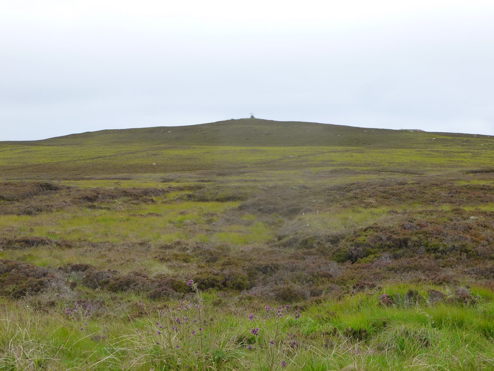
My last moor, Warth Hill

Just as it says. A moment of deliverance
With Veronica at the John o'Groats signpost

I was surprised and absolutely delighted that my brother-in-law John had taken the trouble to join us at John o'Groats! He had driven over from Cape Wrath where he and his family were spending their summer holiday and his arrival was a huge surprise! His welcome included a tot of Lagavulin Malt Whiskey which seemed somehow appropriate to the occasion!

Duncansby Head, the north-east corner of Scotland

A view westwards from Duncansby Head

Veronica appreciating the view

Looking out to sea at our celebratory supper
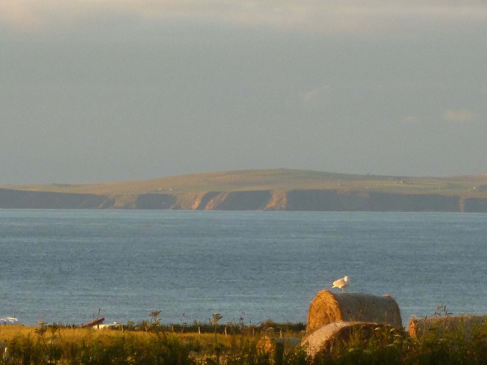
The island of Stroma, north of the mainland

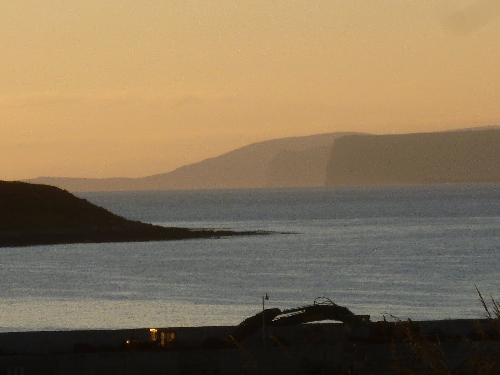
Houses along the north coast in the evening sunshine
Thank you, sincerely, for accompanying me on my journey......
Subscribe to:
Posts (Atom)